


Page 108 - รายงานประจำปี สำนักการวางผังและพัฒนาเมืองปี 2568
P. 108
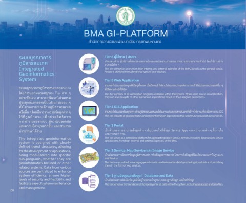
ระบบบูรณาการ                                       Tier 6 ผู้ใชื่้งาน | Users
            ภัูมิิสารสนเทศ                                     ปีรุะกัอบด้วิย ผ่้ใช้้งานทั�งหน่วิยงานภายในแล้ะหน่วิยงานภายนอกั กัทม. แล้ะปีรุะช้าช้นทั�วิไปี โดยใช้้งานผ่าน
                                                               อุปีกัรุณ์์ต้่าง ๆ
            Integrated                                         This tier comprises users from both internal and external agencies of the BMA, as well as the general public.
            Geoinformatics                                     Access is provided through various types of user devices.
            System                                             Tier 5 Web Application

                                                               ส่วินขัองโปีรุแกัรุมปีรุะยุกัต้์ท่�ม่อย่่ทั�งหมด เม่�อม่กัารุเขั้าใช้้งานโปีรุแกัรุมปีรุะยุกัต้์สามารุถ่เขั้าถ่ึงโปีรุแกัรุมปีรุะยุกัต้์อ่�น ๆ
            รุะบบบ่รุณ์ากัารุภ่มิสารุสนเทศออกัแบบ
                                                               ท่�ม่ได้ต้ามสิทธิิท่�ได้รุับ
            โดยกัารุแยกัหมวิดหม่่ขัอง Tier ต้่าง ๆ             This tier consists of all application programs available within the system. When users access an application,
            อย่างช้ัดเจัน  สามารุถ่พััฒนาโปีรุแกัรุม           they can also navigate to other authorized applications based on their assigned permissions.
            ปีรุะยุกัต้์แยกัออกัเปี็นโปีรุแกัรุมย่อย ๆ
            ทั�งโปีรุแกัรุมทางด้านภ่มิสารุสนเทศ                Tier 4 GIS Application
            หรุ่ออ่�น ๆ โดยม่กัารุรุวิบรุวิมขั้อม่ล้ต้่าง ๆ    ส่วินขัองโปีรุแกัรุมปีรุะยุกัต้์ทางด้านภ่มิสารุสนเทศแล้ะโปีรุแกัรุมปีรุะยุกัต้์สารุสนเทศท่�ม่กัารุใช้้งานเครุ่�องม่อทางด้าน  GIS
            ไวิ้ท่�ศ่นย์กัล้าง  เพั่� อปีรุะสิทธิิภาพั         This tier consists of geoinformatics and other information applications that utilize GIS tools and functionalities.
            กัารุทำางานขัองรุะบบ ม่ควิามปีล้อดภัย
            แล้ะควิามย่ดหยุ่นมากัขัึ�น แล้ะสามารุถ่            Tier 3 Portal
            บำารุุงรุักัษาได้ง่าย                              เปี็นส่วินขัองกัารุรุวิบรุวิมขั้อม่ล้ต้่าง ๆ ทั�งรุ่ปีแบบไฟื้ล้์ขั้อม่ล้  Service  Apps  จัากัหน่วิยงานต้่าง ๆ ทั�งภายใน
                                                               แล้ะภายนอกั กัทม.
            The  integrated  geoinformatics                    This tier serves as a centralized platform for aggregating data in various formats, including data files and service
                                                               applications, from both internal and external agencies of the BMA.
            system  is  designed  with  clearly
            defined tiered structures, allowing
            for the development of applications,               Tier 2 Service, Map Service แล่ะ Image Service
            being  modularized  into  specific                 เปี็นส่วินขัองกัารุจััดกัารุขั้อม่ล้ภ่มิสารุสนเทศ หรุ่อขั้อม่ล้สารุสนเทศ โดยกัารุดึงขั้อม่ล้ท่�จััดเกั็บมาเผยแพัรุ่ในรุ่ปีแบบ
            sub-programs,  whether  they  are                  ขัอง Services
            geoinformatics-focused  or  other                  This tier is responsible for managing geoinformatics and information data by retrieving stored data and publishing
                                                               them in the form of web services.
            related systems. Data from various
            sources are centralized to enhance
            system  efficiency,  ensure  higher                Tier 1 ฐานข้้อมิูล่แล่ะข้้อมิูล่ |  Database and Data
            levels of security and flexibility, and            เปี็นส่วินขัองกัารุจััดเกั็บขั้อม่ล้ท่�ม่อย่่ ในรุะบบ ในรุ่ปีแบบขัองฐานขั้อม่ล้ แล้ะไฟื้ล้์ขั้อม่ล้
            facilitate ease of system maintenance              This tier serves as the foundational storage layer for all data within the system, including databases and data files.
            and management.
      108

