


Page 68 - รายงานประจำปี สำนักการวางผังและพัฒนาเมืองปี 2568
P. 68
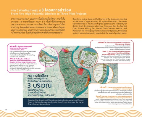
จัาก 5 ย่านศักยภัาพัสูง สู่ 3 โครงการนำาร่อง

            From Five High-Potential Districts to Three Pilot Projects


            จัากักัารุทบทวิน ศึกัษา แล้ะสำารุวิจัพั่�นท่�ในเขัต้พั่�นท่�ศึกัษา รุวิมทั�งสิ�น  Based on a review, study, and field survey of the study area, covering
            ปีรุะมาณ์  18  ต้ารุางกัิโล้เมต้รุ  พับวิ่า  ม่  5  พั่�นท่�  ท่�ม่ศักัยภาพัแล้ะ  a total area of approximately 18 square kilometers, five areas
                                                                           were identified as having the highest potential and suitability for
            เหมาะสมต้่อกัารุวิางแนวิทางกัารุพััฒนาในรุะดับย่านส่งสุด  ได้แกั่
                                                                           district-level development planning. They were Ban Bu, Somdet
            ย่านบ้านบุ  ย่านสมเด็จัเจั้าพัรุะยา ย่านคล้องสาน ย่านมหาดไทย-เจัรุิญนครุ
                                                                           Chao Phraya, Khlong San, Mahat Thai–Charoen Nakhon, and
            แล้ะย่านวิงเวิ่ยนใหญ่ แล้ะจัากักัรุะบวินกัารุปีรุะเมินศักัยภาพัได้คัดเล้่อกั
                                                                           Wongwian Yai. Through a potential assessment process, three pilot
            “3 โครุงกัารุนำารุ่อง” ในรุะดับผังปีฏิิบัต้ิกัารุเช้ิงพั่�นท่�เฉพัาะแห่งขัองเม่อง    projects were subsequently selected at the level of project plans.


                                                                                                     บูริเวณที่่� 2 : โครงการปรับูปรุงภัูมิิที่ัศน์ริมิแมิ่นำาเจ้าพิ่ระยุา
                                                                                                                       ชื่่วงสะพิ่านพิุ่ที่ธ - ที่่าดิินแดิง
           บูริเวณที่่� 1 : โครงการปรับูปรุงภัูมิิที่ัศน์                                                   ต้่อเน่�องจัากักัะด่จั่นมาทางอุทยานเฉล้ิมพัรุะเกั่ยรุต้ิ
           ริมิคล่องบูางกอกน้อยุ ชื่่วงสะพิ่าน                                                    สมเด็จัพัรุะศรุ่นครุินทรุาบรุมรุาช้นน่ ผ่านมัสยิดกั่วิต้ิล้อิสล้าม ศาล้เจั้ากัวินอ่
           คล่องบูางกอกน้อยุ - ศิริราชื่                                                                         สวินสาน มัสยิดเซึ่ฟื้ี ไปีจันถ่ึงท่าเรุ่อดินแดง
           ต้รุงขั้ามกัับพัิพัิธิภัณ์ฑ์์สถ่านแห่งช้าต้ิ เรุ่อพัรุะรุาช้พัิธิ่                            Area 2: The Chao Phraya Riverfront Landscape
                                                                                                               Improvement Project (Memorial Bridge–
           ต้ิดกัับท่�ดินขัองกัารุรุถ่ไฟื้แห่งปีรุะเทศไทย
           ผ่านโรุงรุถ่จัักัรุธินบุรุ่ ต้่อเน่�องไปีจันถ่ึงชุ้มช้นบ้านบุ                                 Tha Din Daeng Section), covering the area from the
                                                                                                        Kadeejeen neighborhood toward The Princess Mother
           ต้ล้าดไรุ้คาน แล้ะ คล้องวิัดทอง                                                                 Memorial Park, passing Goowatil Islam Mosque,
           Area 1: The Bangkok Noi Canal                                                               Guan Yu Shrine, Suan San Pocket Park, Saifee Mosque,
           Waterfront Landscape Improvement Project                                                       and extending to Din Daeng Pier (Tha Din Daeng).
           (Bangkok Noi Canal Bridge–Siriraj Section),
           covering the area opposite the National Museum
           of Royal Barges, adjacent to State Railway of
           Thailand land, passing through the Thonburi
           Locomotive Depot and extending to Ban Bu Community,
           Rai Khan Market, and Wat Thong Canal.


                                                                                                       บูริเวณที่่� 3 : โครงการปรับูปรุงภัูมิิที่ัศน์ริมิแมิ่นำาเจ้าพิ่ระยุา
                                                                                                                    ชื่่วงเจริญนคร 1 - คล่องบูางล่ำาภัูล่่าง
                                                                                                 เพั่�อเช้่�อมโยงพั่�นท่�รุิมแม่นำาเจั้าพัรุะยาด้วิยกัารุเดิน โดยพััฒนาทางเดินรุิมนำา
                                                                                                     พัรุ้อมพั่�นท่�สวินขันาดเล้็กั จัุดแวิะพัักัรุะหวิ่างทางเดิน ไฟื้ฟื้้าส่องสวิ่าง
                                                                                                                       รุะเบ่ยงกัันต้กั จัุดทิ�งขัยะ เปี็นต้้น
                                                                                                   Area 3: The Chao Phraya Riverfront Landscape Improvement
                                                                                                    Project (Charoen Nakhon 1–Bang Lamphu Lang Canal Section),
                             Results of the Selection of Three Areas for the Implementation of Project   River through the development of a riverside walkway, together with
                                                                                                  aiming to enhance pedestrian connectivity along the Chao Phraya
                             Plans in the Ban Bu Area, the Somdet Chao Phraya Area, and the Mahat   pocket parks, pedestrian rest areas, lighting systems, safety railings,
                             Thai–Charoen Nakhon Area                                                          waste disposal points, and related facilities.


      68

